Sensing Planet Earth – Water and Ice
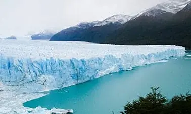
Where do we find water on our planet? Should we worry about rising sea levels? Can we predict climate change? Learn how to measure and monitor the Earth’s water and ice masses.
Subject area
Energy & Sustainability
Course Duration
36 hours
6 weeks
Location
Online
About this course
Global warming. Rising sea levels. Droughts. Flooding. The melting of the polar ice caps.
Join us, when we discover how continental water and ice masses are measured and monitored through remote sensing. Our experts give you first-hand insights how water and mass transport can be traced, and how this relates to the complex processes in the Earth‘s system.
Together with your fellow learners you will assess and evaluate statements made in relation to climate change. This will prepare you to make evidence-based decisions for a sustainable future.
Join us and let’s sense planet Earth together!
What you’ll learn
- How we measure the hydrosphere and the cryosphere
- How to judge the quality and reliability of earth observations
- How to compare measurement tools
- How to assess the impact of global change on our environment
Language of instruction
The cause is taught in English
Lecturers
Anders Berg
Researcher
Anders Berg was a postdoctoral scholar in the Radar Remote Sensing group. His main research topic was sea ice monitoring using spaceborne SAR.
Gisela Carvajal
System Engineer at Saab
Gisela Carvajal was with the Radar Remote Sensing Group as a post-doctoral researcher. Her main research topic was sea surface from space-borne radars (e.g. Synthetic Aperture Radar, Scatterometers) and infrared radiometer sensors. Her main research focused on development of algorithms for retrieval of surface winds and currents. She has a background in Electrical Engineering and a master on Information Technologies.

Karine Le Bail
Senior Researcher
Karine Le Bail is a Senior Researcher at Chalmers University of Technology. She joined the Space Geodesy group at the Onsala Space Observatory in June 2020. Her research activities are focused on the geodetic technique of the Very Long Baseline Interferometry Global Observing System (VGOS), with special emphasis on topics as radiosource structure and atmospheric turbulence. Karine is also a member of the International DORIS Service Governing Board.
Thomas Hobiger
Prof. at University of Stuttgart
Thomas Hobiger was Associate Professor for Space Geodesy at Chalmers University of Technology from 2014 to 2018. He is now with the University of Stuttgart, Germany. He received the M.Sc. and Ph.D. degrees in geodesy and geophysics from the Vienna University of Technology, Vienna, Austria, in 2002 and 2005, respectively. He spent then 8 years at a Japanese research institute, then moved to Chalmers in 2014. There he played an active role in the development of the next-generation space-geodetic systems (in particular VLBI and GNSS) and processing tools for such techniques. His interests: VLBI, GNSS, Earth rotation, sea-level change and GNSS-R, software-defined radio, reference frames, high-performance computing, propagation of radio waves, and time and frequency transfer.
Register today
Register now
Who is this course for?
Course Participant profile
No prior experience required